THE RIGHT STREET
OUR PHILOSOPHY
Conventional G&G technologies establish a solid foundation from which to build. But due to the topographical and geological complexities of central Utah, history has shown that these methods alone are insufficient.
At RB Alliance, our philosophy on technology is illustrated through the symbolism of our logo. In isolation, any given technology only provides a partial picture of the subsurface environment. By supplementing traditional G&G methodologies with next-generation DHM and DMT exploration technologies, we can build a powerful “interlocking” perspective - much stronger and more complete than any individual approach.
We believe it’s time to redefine the boundaries and think outside the box.
DIRECT HYDROCARBON MAPPING (DHM)
HOW IT WORKS
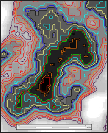
Over long periods of time, sub-surface hydrocarbons cause changes in surface landscapes through natural geophysical, geochemical, and geo-botanical processes. These changes or “anomalous features” are detectible as variations in naturally-occurring, ground-level electromagnetic radiation (EM). DHM is a process developed in the 1990s to detect and interpret these variations using satellite imagery and next-gen processing algorithms. Over the past 30 years, DHM has been refined and implemented in hundreds of projects spanning five continents.
A typical DHM survey selects and processes numerous satellite images of a target area taken over a period of years to search for EM anomalies and Hydrocarbon Lead Indicators (“HLIs”). HLIs range in quality, characteristics, and size, and are tested against high-resolution landscape images to identify “true” hydrocarbon anomalies. The anomalies are then mapped and high-graded, providing an inventory of strong exploration leads and prospects.
Because DHM surveys are not constrained by topography or surface access, extensive, under-explored hydrocarbon regions can be assessed at relatively low cost.
BENEFITS OF DHM
Broad regional coverage
Detects and maps prospectivity zones
Few terrain limitations
Greatly reduces exploration risk
No environmental impact
DIGITAL MAGNETOTELLURIC (DMT)
HOW IT WORKS
Magnetotellurics (MT) have been used in subsurface assessments since the late-1940s. Over the years, significant advancements in instrumentation, processing, and modelling have positioned MT surveys as a fundamental tool in a broad range of scientific and exploration-related fields.
Digital Magnetotellurics (DMT) are a next-gen offshoot of magnetotellurics, developed in the early-1990s and fine-tuned over the subsequent decades. DMT is a non-invasive, surface-based imaging technology, using hand-portable tools and high-fidelity audio equipment. Employing unique, highly-advanced algorithms, these instruments record a wide-band signal in the field for both the magnetic and electric components of the earth’s natural electromagnetic field. By focusing on the higher-frequency signal ranges, DMT surveys can collect higher-quality recordings of vastly more wave cycles than conventional MT technologies.
As these time domain signals are filtered, interpreted, and stored, they yield valuable interpretations of the depth, thickness, and porosity of subsurface intervals. The resulting “logs” generate a remarkably accurate picture of the subsurface stratigraphy, providing similar information to traditional well logs, but without having to drill a single hole. Another distinctive feature of DMT is that the reflection amplitudes of magnetic and electric signals react differently to hydrocarbons and water. These differences between oil, gas, and water are readily apparent when the two profiles are cross-plotted, which enables an accurate estimation of the hydrocarbon potential of surveyed intervals in the subsurface.
So not only can we clearly see the zones, we can see what’s in them.
BENEFITS OF DMT
Rapid results
Lightweight, portable equipment
No environmental impact
Low cost
Identifies subsurface stratigraphic changes
Highlights hydrocarbon-rich zones
Enables formation depth mapping


